Posts

Showing posts from June, 2019

Woolloomooloo 1885

Image
This fab Victorian pile of decoration was the original Sydney Fish Markets, just a couple of streets back from the wharves at Woolloomooloo Bay. It lasted until the 1960s, when it was levelled for low-cost housing.  Said low-cost housing. That's progess, 60s-style. 

Sussex Street 1875

Image
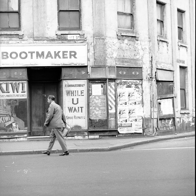
Oh boy, this one took some figuring out. The photo was just labelled ' Washington Place 1875 ', however, while maps from 1865 and 1880 showed there used to be Washington Street and Lane, there was no Place. I could tell by the geography it was near the wharves at Darling Harbour, with Pyrmont in the background.  But I got a match for it with North Street. As you can see on the 1880 map below, both corner buildings on Sussex Street have angled doorways, then going down the lane there are six single storey huts on the left side, then four two-storey houses, with another single-storey building last ( map legend: the number in a circle = the number of storeys ) . At the end of the street is Biggs Foundry. These all match the photo, you can even just make out "Biggs" on the sign over the foundry entrance.  And so today, the surrounding blocks were consolidated into one when Darling Harbour was redeveloped in the 1980s. 

Phillip Street 1984

Image
It was awesome to find this rare photo. Though taken in the 80s, it shows the reconfigured Philip Street at Chifley Square as it was originally made in the 1960s. The building ahead is the old Commonwealth Government Centre, where we got passports etc. The old interwar building to its right is a remnant from Phillip Street's original alignment and stood on the corner with Hunter. Both modernist buildings on either side went up in Sydney's rebuilding rampage of the 1960s.  - and yet none of those buildings above survive, just as their 19th century predecessors they'd replaced . 

Circular Quay 1857

Image
Looking east from Dawes Point. I've enhanced the picture from a small faded stereograph. That's a lot of shipping, especially given that Darling Harbour, Pyrmont and Millers Point were full of wharves at the same time too. And the same spot - 

Bulletin Place 1962

Image
Such a poetic photo of a time past. A common scene then, as Sydney was quite an industrial city, but rare now as its real estate has become so valuable.  The building below, Export House, went up in July 1965 as the Flotta Lauro Building, not long after the photo above would have been taken. 

Darlo Rd 1920

Image
The Bourbon and Beefsteak back when it was a private hospital And as we've known it since the 60s

Macquarie Street 1938

Image
The 1938 Sydney Gay & Lesbian Mardi Gras parades down Macquarie Street, turning the corner from the newly demolished buildings that made way for Martin Place. As you can see, drag in those days was more about glamorous female impersonation, something elegante , other than today's evolution of drag as outre clowns. Anyhoo, here's that spot recently -     

Bondi Rd 1932

Image
It took me ages to work out where this was taken. Today. Yes, really.

Pitt Street 1935

Image
Few people today realise that in pre-war Sydney, police were armed with very long whips. Give them any lip, like this salty brigand, and you'd cop a smart lash around the ear.   And for the record - 

King Street at Pitt 1870s

Image
The vacant corner lot on the right would soon become a fairly grand building for an insurance company. That building, as well as the one on the left, are still there today. 

Museum Station 1933

Image
This picture should enlarge for clearer detail. I always open the image link in a seperate tab, and if necessary then right-click for View Image, to get the full original. Google always seems to condense images otherwise (boo). With Mark Foys across the road (now the Downing Centre Courts), and Snows and Horderns department stores just down Liverpool Street, and Buckinghams and McIlwraiths up on Oxford, this was a very busy shopping area in its day. The 1870s church in the centre-right burnt down a few years after this photo was taken, the land sold and retail premises built in its place. Everything along the right then came down in the late sixties, except the Paris Theatre (designed by Burley-Griffin in 1914) - the short white building at the far-end of the block - which lasted until the early eighties. Across the road from it, the Burdekin pub (with the Tooths KB sign), itself a Federation-style replacement for the original Victorian one that was demolished when Oxford stre...

North Bondi 1960

Image
The tram terminus Became a bus terminus shortly after The chemist is still there, too.

Bligh Street from 1872

Image
Campbell House, 1872 By the 1890s, the Union Club had replaced it. Its last hurrah, 1957 By 1962, it was a parking lot. Until the Wentworth Hotel was built in 1965

Bathurst Street at George from 1870

Image
Around 1870  And a couple of decades later  And a bit later still 

Darlinghurst 1859

Image
The Husband family outside Oak Cottage, Liverpool Street, Darlinghurst, around 1859.

Rushcutters Bay 1957

Image
 

Bent Street 1969

Image
 

Kings Cross 1945

Image